CHAPPIDI ABHIRATH REDDY
C/O COL GKS REDDY
Secunderabad - 500 015.
Visit to Chirapunjee - D + 14 (24 Mar 2013)
(a) I had early breakfast and started by Taxi at 0700h for Chirapunjee along with Col Arora and family. Though some of the Rain forests at Chirapunjee are still exixting, the area generally has been mostly de – forested and in most places, it is looking more like a desert and it definitely is NO more a place with heaviest rainfall in the world. Most of the hills are barren and devoid of the rain forests and the waterfalls are either dried up or just a trickle.
(b) It was quite sad to see the manmade disaster all around. We had Lunch outside Mawsmai Cave, saw Noh Ka Likai Falls, Dainthlen Falls, Rama Krishna Mission, before returning to Shillong by evening.
Chirapunjee
Cherrapunji (/tʃɛrəˈpʌndʒi, tʃɛrəˈpʊndʒi/,  second pronunciation (help·info); currently the historical name Sohra is more commonly used; alternative spellings are Cherrapunjee and Charrapunji), is a subdivisional town in the East Khasi Hills district in the Indian state of Meghalaya. It is credited as being the second wettest place on Earth. However, nearby Mawsynram currently holds that record. Though, it still holds the world record for the most rainfall in a calendar month and in a year. It received 9,300 mm (366 in) in July 1861 and 26,461 mm (1,041.75 in) between 1 August 1860 and 31 July 1861.
The original name for this town was Sohra, which was pronounced "Churra" by the British. This name eventually evolved into the current name, Cherrapunji. The word "cherrapunji" means 'land of oranges'. Despite perennial rainfall, Cherrapunji faces an acute water shortage and the inhabitants often have to trek for miles to obtain potable water.[2] Irrigation is also hampered due to excessive rain washing away the topsoil as a result of human encroachment into the forests. The Meghalaya state government has renamed Cherrapunjee back to its original name, "Sohra"
Some of the surviving Greenery at Chirapunjee
With Col & Mrs Arora with some of the surviving Rain Forests of Chirapunjee in the Background
With Family of Col Arora with a barren hillside in the background - A Manmade Disaster
Another View of the Barren Hillsides at Chirapunjee
What was once a Rain Forest - Now a totally barren Hillside - A Man Made Disaster
Dain Thlen Falls
The fall got its name from python, as in Khasi language Theln means python. History says that a demon named Thelm was swept out from a deep crevice of the rock and taken along with the fast moving water to the rock beside this waterfall to be killed there. The tourists can spot the marks left on those rocks where that evil spirit was killed. These marks symbolize evil, greed and corruption.
At Dainthlen Waterfalls, See the Bare Hills and only a Trickle of Water
Self, Reeth & Anju at Dainthlen Falls
Col Arora & Family at Dainthlen Falls
At Dainthlen Waterfalls
Rama Krishna Mission, Chirapunjee
The Ramakrishna Mission is an important landmark overlooking the hills of Cherrapunjee. Started in 1924 by Swami Vivekananda, this institution has grown into a major tourist attraction.
The sight of the institution catches the eye of everyone entering Cherrapunjee. The majestic structure of Ramakrishna Mission is a sight to behold. The vastness and splendour of Ramakrishna Mission can be gauged from the fact that most of the tourist enquire about the place and are inquisitive to capture it through their lens.
With Rama Krishna Mission & Rain Forest in the Background
At Chirapunjee, with Rama Krishna Mission in the Background
With a Group of Khasi Tribals on the way to Rama Krishna Mission
At the Entrance of Rama Krishna Mission in Chirapunjee
Nohkalikai Falls is the tallest plunge waterfall in India. Its height is 1100 feet (335 metres). The waterfall is located near Cherrapunji, one of the wettest places on Earth. Nohkalikai Falls are fed by the rainwater collected on the summit of comparatively small plateau and decrease in power during the dry season in December - February. Below the falls there has formed a plunge pool with unusual green colored water.
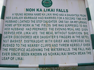
Name of the falls (in Khasi language - "Jump of Ka Likai") is linked to a legend about local women Likai who after family tragedy became insane and jumped off the cliff next to the falls.
A brief summary of the tragic legend is as follows: A woman named Ka Likai remarries. But the new husband is jealous of her love for her daughter. While Ka Likai is out working, her new husband kills the daughter and cooks her flesh into a meal. The woman comes home and asks her husband if he knows where the daughter is. He says no, but before she goes out looking, she should have something to eat. After eating, she finds her daughter's fingers in the betel-nut basket. In despair, the woman threw herself off this cliff giving the falls its name: "Fall of Ka Likai"
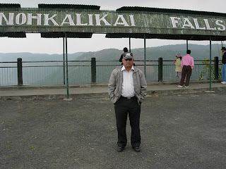
At Noh Ka Likai Waterfalls, Chirapunjee
Mythology about Noh Ka Likai Waterfalls
At Noh Ka Likai Waterfalls
Another View of Noh Ka Likai Waterfalls
Water Pool at the Bottom of Noh Ka Likai Water Falls
Another View of Noh Ka Likai Falls, when the weather packed up
A closeup of Noh Ka Likai Water Falls
Mawsmai Caves
Mawsmai caves near Cherrapunji is an experience in itself, the limestone caves are well lit up by the Meghalaya Tourism, but if you want to thrill yourself more, climb up to the caves which are not lit up, they are guaranteed to spook you as one has to crawl their way in. Staircases can also be found inside as they were used while exploring the caves, nice place to play hide and seek, don't forget to carry a torch though
At the Entrance of Mawsmai Cave, Chirapunjee
Inside Mawsmai Cave, Chirapunjee
Interior View of Mawsmai Cave
Back to Mawsmai Cave for Lunch Break at Restaurant Outside
Inside Mawsmai Cave
At Rear Exit of Mawsmai Cave
Rocks Denuded by continuous Water Flow
At Mawsmai Cave
Outside the Restaurant at Mawsmai Cave
D + 15 (25 Mar 2013)
Spent the morning meeting Officers of ARC and bidding Farewell. Had early Lunch and took a Taxi from Shillong to Guwahati Airport, as my Flight to Kolkata was scheduled to take off from Guwahati Airport in the evening. Reached Kolkata Airport at 2200h and went straight to Hoogly View Guest House of Bengal Area.
Spent the morning meeting Officers of ARC and bidding Farewell. Had early Lunch and took a Taxi from Shillong to Guwahati Airport, as my Flight to Kolkata was scheduled to take off from Guwahati Airport in the evening. Reached Kolkata Airport at 2200h and went straight to Hoogly View Guest House of Bengal Area.
Note:- The information about the places visited has been Extracted from Wikipedia The Free Encyclopedia


No comments:
Post a Comment